Web Services - OGC
Introduction
The Open Geospatial Consortium (OGC) is an international not for profit organization committed to making quality open standards for the global geospatial community. These standards are made through a consensus process and are freely available for anyone to use to improve sharing of the world's geospatial data.
Services related to metadata exchange: catalogue services
Metadata acts as generalised properties that can be queried and returned through catalogue services for resource evaluation and, in many cases, invocation or retrieval of the referenced resource. The Catalogue Services for the Web (CSW) is one part (or "profile") of the OGC Catalogue Service, which defines common interfaces to discover, browse, and query metadata about data, services, and other potential resources. Version 2.0 of the specification was released in May 2004. The most recent release is 2.0.2, which was published in 2007.
The ESPON database metadata catalogue will be available through the CSW service. In order to publish the catalogue it is necessary to conform each individual metadata to a recognized standard.
The first part of the process was to map the metadata fields of ESPON database to the INSPIRE metadata profile. This process is fundamental because it allows enhancing ESPON metadata with the necessary interoperability for any possible interaction with other platforms (regardless of the type of protocol used later).
The second part of the process consists in transferring (with a specific periodicity) the entire catalog in an environment that allows the application of the CSW protocol. Among the various options available, the choice of the GeoNetwork platform is currently the most interesting.
The GeoNetwork opensource catalogue publishes metadata using, among several other services, the OGC CSW protocol compliant with the 2.0.2 version of the specification. It supports the following CSW operations:
The CSW operations can be accessed using POST, GET methods and SOAP encoding. Presently it is possible to access the CSW (GetCapabilities) component of the ESPON metadata catalogue through the following URL:
Example 1: visualize metadata (INSPIRE) through GeoNetwork
Example 2: retrieve metadata (INSPIRE) in xml format
Services related to geographic data exchange: map, feature and coverage services
Geographic data will be shared across different platforms using standard protocols established by the OGC. These services that are implemented in the ESPON database, through a dedicated GeoServer, include: :
- The Web Map Service (WMS) – supports requests for map images (and other formats) generated from geographical data.
- The Web Feature Service (WFS) – supports requests for data with vector geometry and attributes.
- The Web Coverage Service (WCS) – supports requests for raster data.
These OGC Web Services are made available by means of a dedicated Geoserver installed at the University of Geneva.
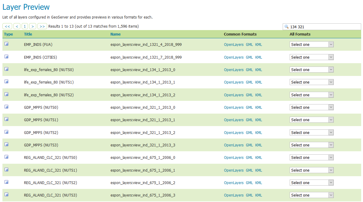
Currently 28 layers are available for both WMS and WFS services as summarized in Table 1
Geographic unit | Nomenclature version |
NUTS0 | |
NUTS1 | |
NUTS2 | |
NUTS3 | |
LAU2 | |
| FUA | 2011-2014, 2015-2018 |
CITIES | |
UMZ | |
Metro Regions |
Table 1: Geospatial layers available through WMS and WFS services
Another feature allows retrieving geometries and thematic attributes of each indicator in the database.
It is therefore possible to retrieve the entire data (geometries and attributes) for a precise indicator, by specifying the temporal interval, and the type of nuts.... This part is described in the next section
Services for single indicators
Every published standard indicator has associated WMS/WFS webservice in ESPON Geoserver. WMS indicator service is available by indicator and level (figure 1.
They can be called by WMS service or a WFS service for example to download a zip file containing geometries in shape file and attribute table. For a example, WMS for indicator life_exp_females_80 NUTS1:
In the above URL the section: view_ind_1_2013_134_1 refers to the NUTS (nomenclature_id 1) version (2013) indicator code (134) and level (1).
The Geoserver output is displayed in figure 2:
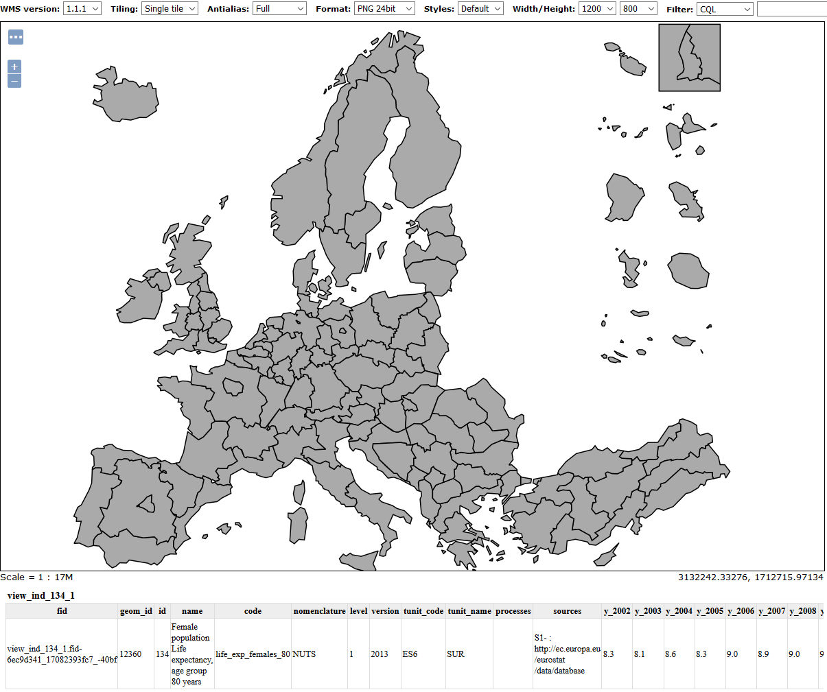
Figure 2: WMS for indicator life_exp_females_80 NUTS1
Services for spatial extension
Every spatial extension has associated WMS/WFS webservice in ESPON Geoserver through a parametric view. WMS indicator service is available by indicator and level (Figure 1.
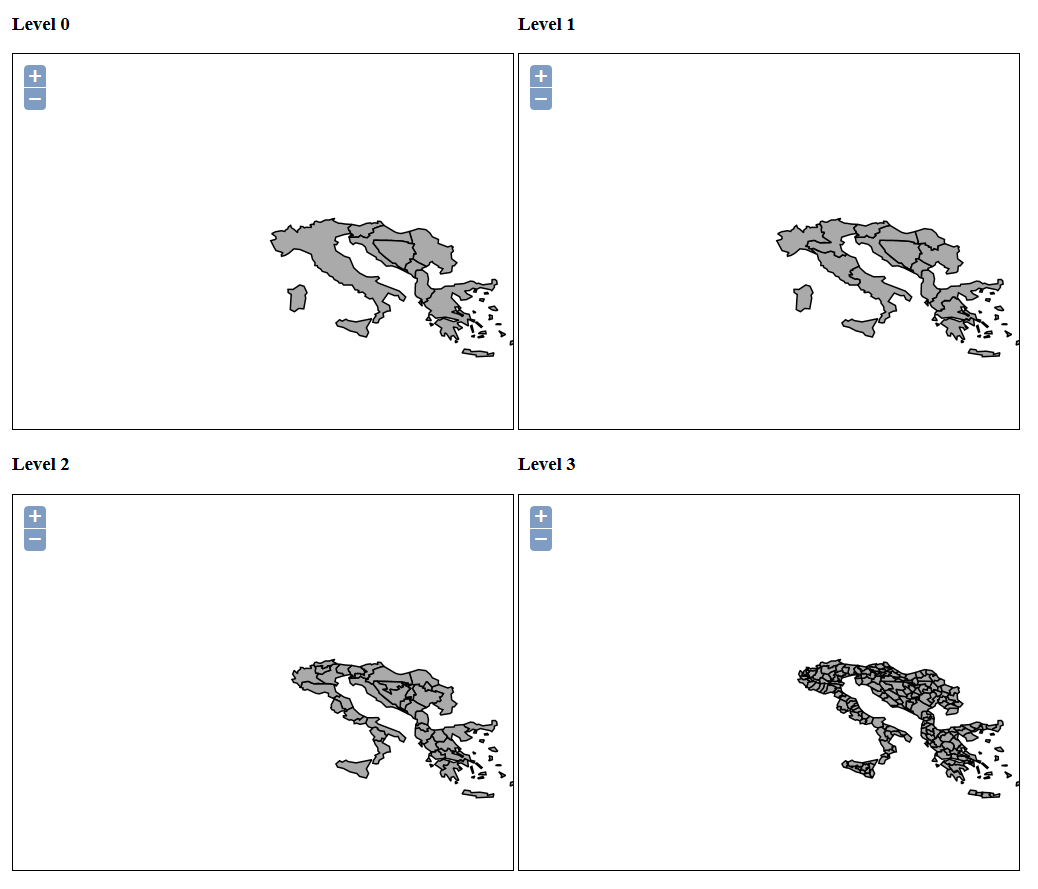
Figure 3: WMS for saptial extention Adriatic-Ionian (NUTS 2013)
They can be called by WMS service or a WFS service for example to download a zip file containing geometries in shape file and attribute table. For a example, WMS for spatial extension Adriatic-Ionian NUTS 0 version 2003:
In the above URL the section: 102 refers to the spatial extension code.
Spatial extension available
| 1 | EU28+4 |
| 2 | EU28+4+CC |
| 5 | EU28 |
| 101 | North Sea |
| 102 | North West Europe |
| 103 | Northern Periphery and Arctic |
| 104 | Baltic Sea |
| 105 | Danube Area |
| 106 | Atlantic Area |
| 107 | Alpine Space |
| 108 | Central Europe |
| 109 | Adriatic-Ionian |
| 110 | Balkan Mediterranean |
| 111 | South-West Europe |
| 112 | Mediterranean Area |
| 113 | EUSBSR |
| 114 | EUSDR |
| 115 | EUSAIR |
| 116 | EUSALP |