OGC Web Services
The Open Geospatial Consortium (OGC) is an international not for profit organization committed to making quality open standards for the global geospatial community. These standards are made through a consensus process and are freely available for anyone to use to improve sharing of the world's geospatial data.
Nomenclatures
The most important geographic feature framework at EU level is the NUTS classification. The main ESPON 2020 database includes these geographic features in the dedicated GIS schema, data will be converted to PostGIS tables, which will be related to the Standard Data tables.The table below includes the GIS datasets and their version, which are incorporated in the ESPON 2020 database (https://ec.europa.eu/eurostat/web/gisco/geodata/reference-data/administrative-units-statistical-units/nuts#nuts13 ).
GIS datasets and their versions (NUTS)
STATISTICAL UNIT | SCALE | REGIONAL LEVEL | PERIOD | COORDINATE REFERENCE SYSTEM | VERSION DATE | SOURCE |
NUTS 2013 | 1:3 Million | 0, 1, 2, 3 | 2013 | ETRS89 | 03.12.2015 | Eurostat/GISCO |
1:20 Million | 0, 1, 2, 3 | 2013 | ETRS89 | 03.12.2015 | Eurostat/GISCO | |
NUTS 2010 | 1:3 Million | 0, 1, 2, 3 | 2010 | ETRS89 | 21.12.2011 | Eurostat/GISCO |
1:20 Million | 0, 1, 2, 3 | 2010 | ETRS89 | 21.12.2011 | Eurostat/GISCO | |
NUTS 2006 | 1:3 Million | 0, 1, 2, 2/3, 3 | 2006 | ETRS89 | 01.01.2008 | Eurostat/GISCO |
1:20 Million | 0, 1, 2, 2/3, 3 | 2006 | ETRS89 | 01.01.2008 | Eurostat/GISCO | |
NUTS 2003 | 1:3 Million | 0, 1, 2, 3 | 2003 | ETRS89 | 01.07.2007 | Eurostat/GISCO |
1:20 Million | 0, 1, 2, 3 | 2003 | ETRS89 | 01.07.2007 | Eurostat/GISCO | |
NUTS 1999 | 1:20 Million | 0, 1, 2, 3 | 1999 | ETRS89 | M4D |
Recent license agreement between GISCO and EuroGeographics (http://www.eurogeographics.org/content/eurogeographics-euroglobalmap-opendata) allows to distribute the NUTS boundary data freely at the scale 1:1 Mio or smaller. This means, among other things, that it will be allowed, to spread tangible copies of these geographic features among the public. GIS files of NUTS will be available for download from the web interface, in the most current GIS formats (shapefile, etc.).
The PostGIS database will also include geometries for the Local Administrative Units (LAU) level 2. LAU 2 is compliant with the lowest administrative level, and In most cases, LAU 2 regions are identical with national administrative levels (Commune) - https://ec.europa.eu/eurostat/web/gisco/geodata/reference-data/administrative-units-statistical-units/communes#communes13.
GIS datasets and their versions (LAU)
STATISTICAL UNIT | SCALE | REGIONAL LEVEL | PERIOD | COORDINATE REFERENCE SYSTEM | VERSION DATE | SOURCE |
LAU 2013 | 1:1 Million | 2 | 2013 | ETRS89 | 03.12.2015 | Eurostat/GISCO |
Moreover, ESPON 2020 also guarantees an access to the geospatial data trough web
services. To ensure they are compliant with OGC standard, geographic features will be further integrated within GeoServer.
Services related to geographic data exchange: map, feature and coverage services
Geographic data are shared across different platforms using standard protocols established by the OGC. These services that are implemented in the ESPON database, through a dedicated GeoServer, include: the Web Map Service (WMS), the Web Feature Service (WFS) and the Web Coverage Service (WCS) .
Get Capabilities endpoint:
Four new layers where added in the list of OGC services including data from: FUA, UMZ, and Metro Regions.
Currently 17 layers are available for both WMS and WFS services as summarized in the Table below.
Table 1: Geospatial layers available through WMS and WFS services
Geographic unit | temporal extent |
NUTS0 | 2003, 2006, 2010 |
NUTS1 | 2003, 2006, 2010 |
NUTS2 | 2003, 2006, 2010 |
NUTS3 | 2003, 2006, 2010 |
LAU2 | 2013 |
FUA | 2015-2018 |
UMZ | 2000, 2006 |
Metro Regions | 2013 |
It is possible to visualise the spatial coverage of those spatial extents through a WMS webservice. For example, for NUT2 version 2006, the URL is (Figure 10): https://database.espon.eu/geoserver/espon_layers/wms?service=WMS&version=1.1.0&request=GetMap&layers=espon_layers:gis_nuts2_2006&styles=&bbox=-2823913.87226075,-3076144.55029697,1.00261246655394E7,5415981.70375715&width=768&height=507&srs=EPSG:3035&format=application/openlayers.
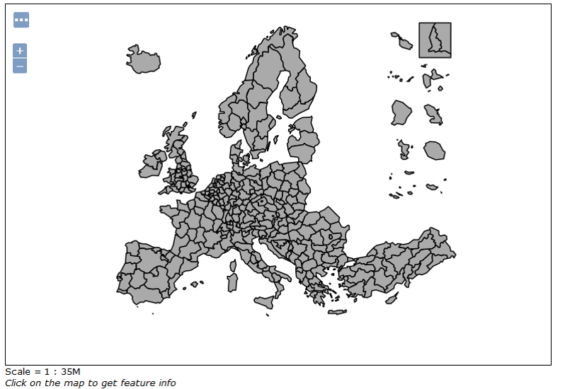
Figure 1: Spatial Coverage for NUTS2, 2006
Every published standard indicator has associated WMS/WFS web services in ESPON Geoserver. WMS indicator service is available by indicator and level (Figure 2).
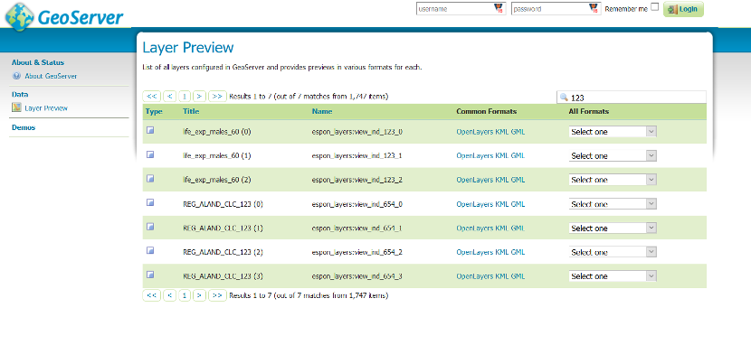
Figure 2: ESPON 2020 Database Geoserver
They can be called by WMS service or a WFS service for example to download a zip file containing geometries in shape file and attribute table. For a example, WMS for indicator life_exp_females_80 NUTS1: https://database.espon.eu/geoserver/espon_layers/wms?service=WMS&version=1.1.0&request=GetMap&layers=espon_layers:view_ind_134_1&styles=&bbox=2641758.46955152,1428695.35991733,7313157.28662197,5456938.51107795&width=768&height=662&srs=EPSG:3035&format=application/openlayers
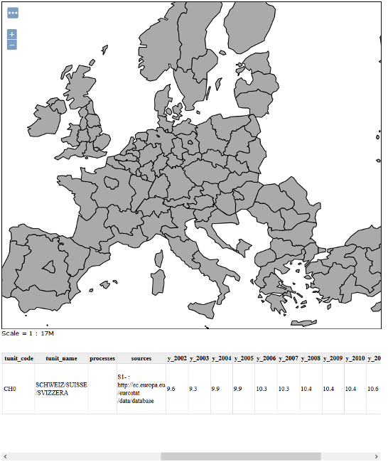
Figure 3: WMS for indicator life_exp_females_80 NUTS1
A new added feature allows retrieving geometries and thematic attributes of each indicator in the database.
It is therefore possible to retrieve the entire data (geometries and attributes) for a precise indicator, by specifying the temporal interval, and the type of nuts.
The following example shows how to get the map within the thematic attributes at NUTS 2 level for 2009 for the indicator 438 (% of regional workforce employed in industry)